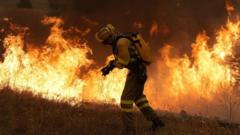
Australia is finally getting smart about bushfires. For decades, emergency services relied heavily on massive water-dropping aircraft, heavy bulldozers, and reactive suppression tactics that often arrived too late. That approach failed. It ignored the reality of a continent built to burn. Now, a quiet revolution is taking shape across the outback and the northern savannas. Land managers are combining ancient Indigenous fire practices with satellite data and advanced mapping software, and the results are changing how the world thinks about wildfire management.
If you want to understand why traditional methods work, you have to look at what happened when European settlers disrupted thousands of years of continuous land management. Aboriginal Australians practiced cultural burning for millennia, using low-intensity fires during the cooler months to clear out dead brush and reduce fuel loads. When colonial authorities banned these practices, dead timber accumulated. The outcome was predictable. Lightning strikes and dry heat turned small flare-ups into catastrophic mega-fires that scorched millions of hectares. Meanwhile, you can explore similar stories here: Why Letting Tech Giants Police Their Own Ai Safety Fails Everyone.
Today, Indigenous ranger groups are back on Country, steering the wheel. But they aren't working alone. They pair generational ecological wisdom with modern satellite tracking and weather prediction models to execute targeted burns with surgical precision.
How Traditional Burning Meets Satellite Tracking
Cultural burning isn't just about setting random fires. It requires an intimate understanding of micro-climates, animal breeding cycles, and specific plant indicators. Rangers know precisely when the soil moisture is right and when winds will cooperate. To see the full picture, check out the excellent analysis by Wired.
Tech steps in to scale these localized practices across vast, remote expanses. Ranger teams use high-resolution satellite imagery to monitor fuel loads before a single match is struck. They track carbon outputs, map burn scars in real-time, and analyze weather patterns using GIS software. This marriage of ancient observation and digital mapping allows organizations like the Yugul Mangi Rangers to cover massive territories safely.
The math speaks for itself. Northern Australian savanna projects now span millions of hectares, cutting massive amounts of greenhouse gas emissions by preventing late-season, high-intensity infernos. By burning early in the dry season when vegetation is patchy and damp, rangers keep fires cool and controllable. Small animals escape. Trees survive. Carbon stays trapped in the soil instead of flooding the atmosphere.
Turning Ecological Care Into Economic Power
You cannot sustain conservation efforts on good intentions alone. It takes funding. Australia's carbon market has turned traditional fire management into a self-funding economic engine.
Under specific federal crediting schemes, Indigenous carbon businesses generate Australian Carbon Credit Units by lowering emissions through early dry season burns. They sell these credits to corporations seeking offsets. The revenue flows straight back into local communities. It funds equipment, pays ranger salaries, and allows Elders to pass cultural knowledge down to younger generations.
This creates a closed-loop system that conventional government agencies struggle to replicate. Cultural knowledge protects the landscape. The landscape sequesters carbon. Carbon credits fund the people doing the work. Everyone wins except the wildfire.
The Real Challenges Facing Cultural Burn Programs
Nothing scales without friction. Expanding these programs nationwide requires navigating bureaucratic red tape and deep-seated institutional resistance.
State-based emergency services have historically viewed fire through a lens of total suppression. Shifting that mindset means convincing career bureaucrats that lighting fires on purpose is safer than trying to put them out later. It also requires respecting Indigenous intellectual property. Too often, outside organizations try to extract traditional knowledge without forming genuine partnerships with the Traditional Owners who hold it.
Training takes time, too. You cannot download centuries of ecological literacy from an app. It takes years of walking the land, listening to Elders, and observing seasonal cues like the singing of specific birds or the flowering of native trees. Technology accelerates logistics, but human experience dictates the outcome.
What Other Fire-Prone Regions Can Learn
California, Southern Europe, and parts of South America face identical wildfire threats driven by climate change and decades of poor land management. They pour billions into air tankers while ignoring the ground level reality.
Australia's hybrid model offers a blueprint. Stop treating fire as an enemy that can be blasted out of the sky with water. Treat it as a tool that needs careful, localized handling. Empower local communities who know the soil. Back them up with modern data systems so they can scale their efforts without losing their cultural foundations.
The formula is simple. Listen to the people who managed the land before maps were drawn, give them the digital tools to monitor the modern climate, and get out of their way.
Stop waiting for the next disaster season to react. Start managing the fuel before the heat arrives.
/Elon Musk%2C founder%2C CEO%2C and chief engineer of SpaceX%2C CEO of Tesla by Frederic Legrand - COMEO via Shutterstock.jpg)