You expect weather to dictate how a fire behaves. When the fire starts dictating the weather, the rules change entirely.
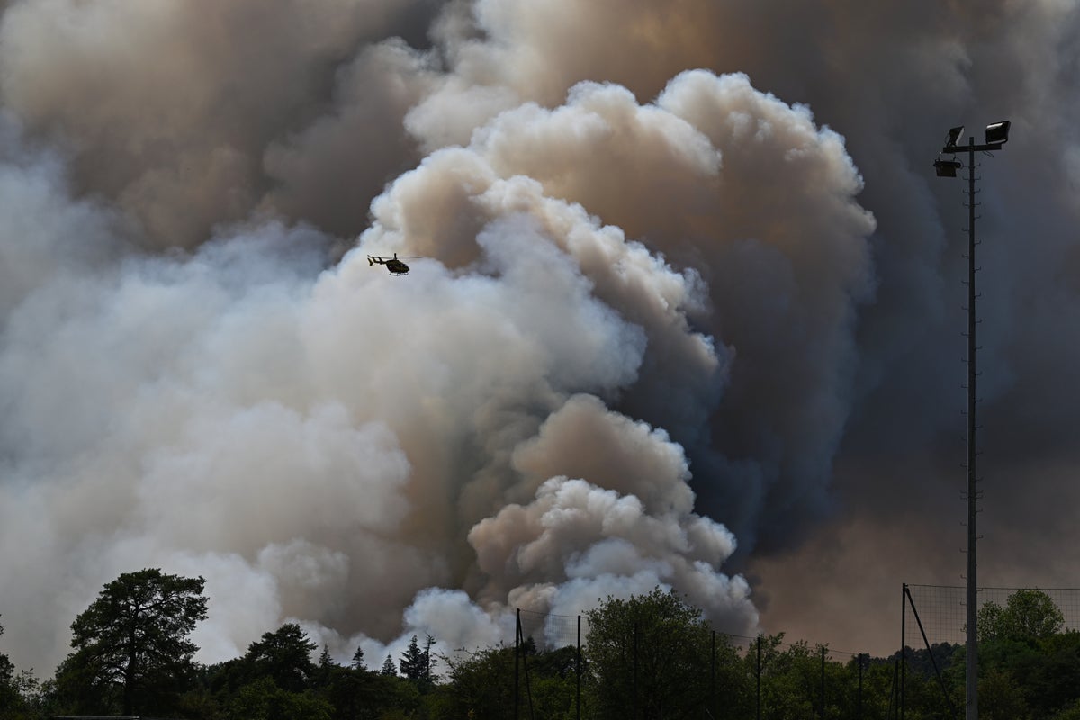
That is what happened in southwest France when a massive blaze near Saumos in the Gironde region grew so violent that its smoke column mutated into an active thunderstorm. The fire didn't just burn forests and destroy homes. It spawned a rare atmospheric beast known as a pyrocumulonimbus, or pyroCb. For another view, check out: this related article.
French emergency officials confirmed that their national firefighters federation had never recorded this phenomenon on home soil before. Historically, these terrifying fire-generated storms were reserved for the apocalyptic wildfire seasons of Australia and North America. Now, they are crossing into Europe.
How a Wildfire Turns Into a Thunderstorm
Most people assume smoke just drifts upward and fades away. But when a wildfire burns hot enough, the mechanics shift. Related reporting on the subject has been shared by NBC News.
Think of it like an industrial-scale chimney. The inferno pumps intense heat, smoke, and moisture straight up into the atmosphere at incredible speeds. As that superheated air climbs into freezing high-altitude layers, water vapor condenses around ash particles.
Colliding ice crystals separate electrical charges, exactly like an ordinary storm. The result is a blackened, electrified tower of cloud lit from the inside. Theodore M. Giannaros, a fire meteorologist at the National Observatory of Athens, calls it a storm cloud born directly from the sheer energy of burning timber.
The Dangerous Feedback Loop
Once a pyroCb forms, it stops being a passive byproduct of the fire. It becomes an active partner in the destruction.
The storm system creates its own violent, erratic wind patterns. Strong updrafts pull fresh air toward the flames while powerful downdrafts slam gusts back down to the surface. These sudden shifts can split a single fire front into multiple directions within minutes.
Worse yet, the lightning generated by the cloud doesn't stay in the sky. It strikes the parched ground far outside the existing perimeter.
That is how a single forest fire manages to reproduce. Bolts strike unburned timber miles away, sparking brand-new blazes that trap firefighting crews and close evacuation routes without warning.
Why Europe Is Seeing This Now
We are watching the atmosphere change in real-time. Prolonged heatwaves, bone-dry vegetation, and extreme temperatures create the exact atmospheric instability needed to breed dry thunderstorms.
Scientists are scrambling to capture long-term data through initiatives like the European research project ROSETTA, trying to figure out how frequently we can expect these monsters in the future.
When a fire generates its own weather, traditional firefighting strategies break down. Evacuations must happen faster, and predictions become obsolete. The landscape has changed, and the fires are writing their own rules.